Tag Archives: ICE

Scanning Large Photos and Documents

We’ve described how to use Microsoft ICE in a previous post: Microsoft ICE  This free program works well with normal photographs but we ran into a problem this week with scans of an old map. Here’s how we managed to work it out.

1. We scanned each side of the map using six separate scans. When we placed it on the scanner, we made sure that the map was square and that each scan overlapped the previous scan. When we finished, we had six full platen scans.

Photo of HK Map Scan
One of the six scans for one side of the full map.

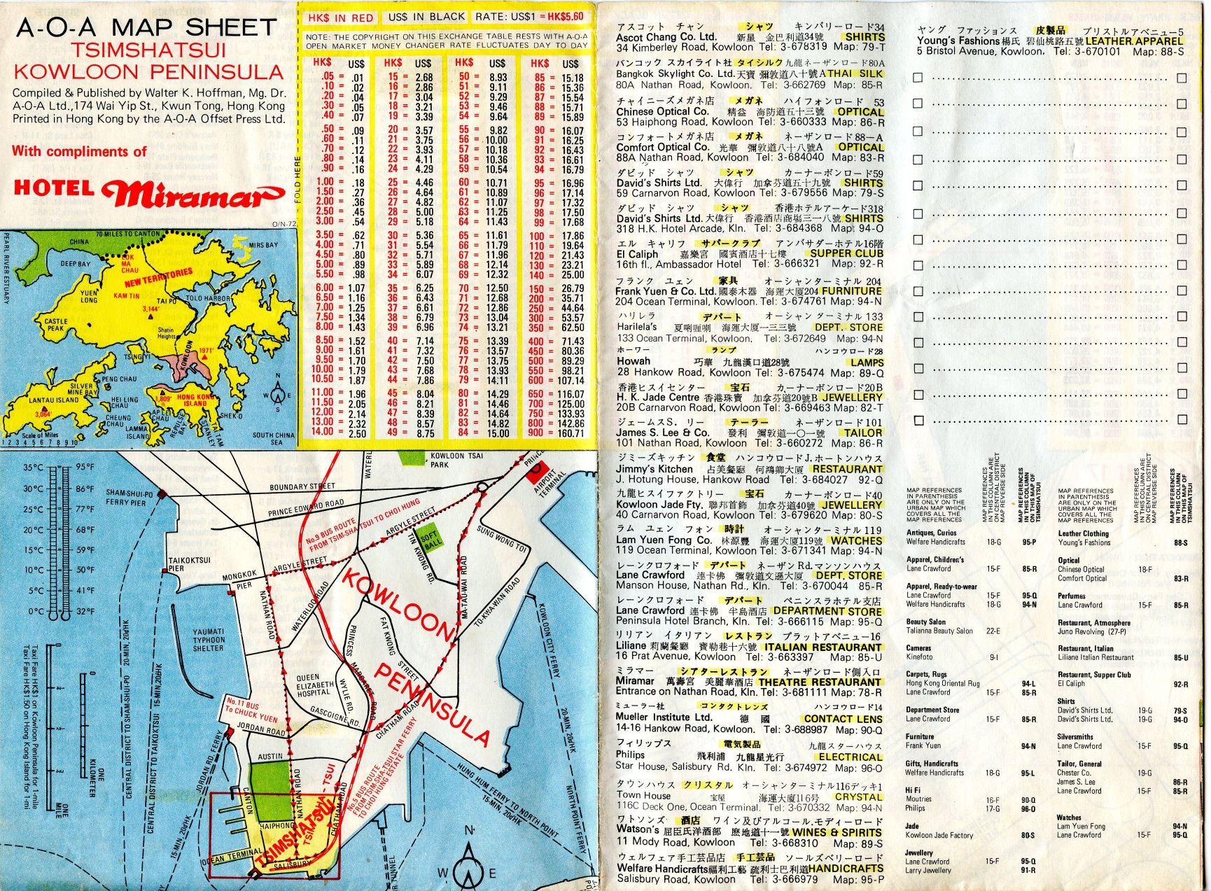
2. In order to ensure that each photograph was oriented the correct way, seeing as how we had to scan some parts of the map upside down, we opened each photo in Irfanview and used the original document as a guide. Some photos had to be turned horizontally left or right. Irfanview is great for looking at photos plus it has many tools with it. We’ll use it later on to make a PDF out of the map. A PDF can handle a large file much better than a JPG photo plus you can zoom in our out at will. For photo editing, however, we use the GIMP. (GIMP is short for Gnu Image Manipulation Program and it’s free.)

3. Once the GIMP was up and running, we created a new file. That new file had to be large enough to accept all six of the scanned documents (photos). The map was about three scans wide and two high. Doing the math created a huge new file. How big was the file? It measured 6920 pixels wide by 5090 high. That’s big!

4. With the file open on one monitor, we opened the folder with the scanned photos in the other monitor. One by one, we dragged each photo from the fold to the new GIMP file. Every time you add a photo to a GIMP file, you create another layer. All of this is done for you, just drag and drop.

5. Once two images were in the new file, we would roughly align them to match each other. With a map, this is pretty easy because of things like roads and location names. Then we added the rest of the scans one by one and arranged them accordingly.

6. After all six scans were in the new GIMP image, we zoomed in and aligned them more precisely. This took a bit of time but, as we said, it’s much easier with a map than it is with a photo.

7. Six separate images mean six layers. A six layered image can’t be saved as a JPG so we had to ‘flatten’ the image into one layer. We double-checked our alignment then selected flatten under the Image tab then saved the image as a JPG file.

Photo of large HK Map.
Here it is, six scanned photos arranged like the original 1972 map.

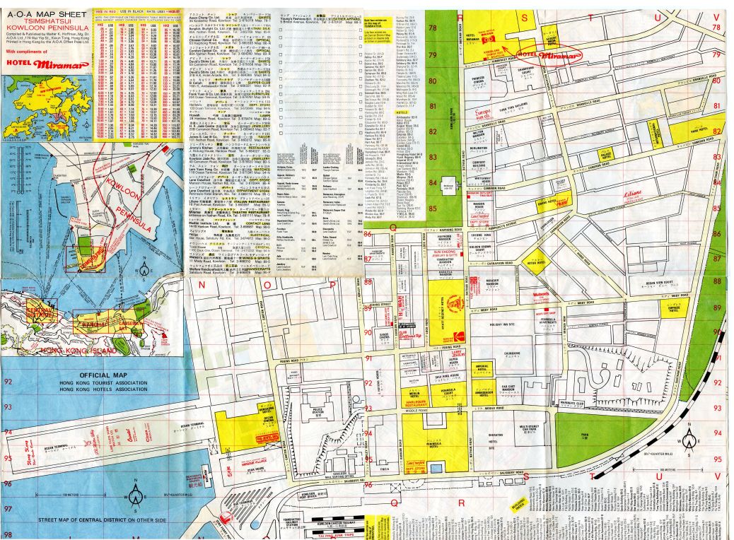
8. Lastly, we used Irfanview to create a PDF from the two large GIMP images, one for the front of the map and the other for the back. Here’s our instructions for that: Creating a PDF with Irfanview

This is a basic outline of what you have to do to scan large documents. Microsoft ICE works perfectly…most of the time. We were surprised that it didn’t seem to be able to handle the maps but, as it turns out, we did well on our own. You will too.

Thanks for reading! If you have questions, ask us.

Follow us on Facebook. Just click Like and you’ll get all our updates and tech tips as soon as we post them:Computers Made Simple on Facebook

Free Panoramic Photos – using Microsoft ICE (Image Composite Editor)

Panoramic photos are now free and very easy to create. You do not need a special camera, any digital camera will do. As a matter of fact, you don’t even need a digital camera if you have a scanner. More on that later. First, let’s look at the panorama photos.

Let’s say that you want to create an image that gives a better feeling of a wide scene, maybe a harbor or a cityscape. Single images just won’t do for something like this. What you want is a full view of what you see when you look from left to right or right to left across a scene. While some digital cameras can create panoramic images by themselves, we’re here to show you how to create a panoramic photo on your own computer, with free software from Microsoft.

Microsoft Image Composite Editor (ICE) is available here:  http://research.microsoft.com/en-us/um/redmond/groups/ivm/ice/   The software is free and is available in either 32 bit or 64 bit versions. Download it and install it.

Next, go out with your digital camera and take about six or seven photos in a row, doesn’t matter which direction you start. Make sure you overlap a bit with each photo on one edge or the other. Keep the same camera height but you don’t have to be totally precise, just do the best you can. Later, you can crop the jagged bits caused by any up or down movement of the camera between snaps. You can do more, maybe even  a complete circle, although we haven’t tried that.  Once you’re done, upload the photos to your computer.

Fire up Microsoft ICE. The program opens with a blank screen. What you’re going to do is drag and drop that series of photos  onto the dark grey space that is shown here:

Photo of ICE 1
Highlight your new photos in their folder and drop them into this window.

As soon as ICE has the images in its hands, it starts to stitch them together. Depending on the speed of your computer, this could take seconds or a couple of minutes. Our seven photos only took about 15 seconds to stitch on a relatively fast computer. Here is how ICE looks when it’s completed its work:

Photo of ICE 2
See the jagged lines at top and bottom? We can crop those out.


Once ICE has completed working, check for jagged lines on the top or bottom of the image. Drag the horizontal line up or down, depending on which edge you are working on, to get rid of the jagginess. Once you’re done that, click on Export to disk, middle right side of the window.

The standard Windows save menu pops up and allows to save the stitched photo to your desktop or other folder. You’re done! Fast, easy and free.

As far as scanning is concerned, many things you want to scan are larger than the flatbed that you lay them on. Carefully line up different scans, making sure you overlap the edges as we did in the photo, and scan away. In this case, it doesn’t matter if the scans are overlapped on top or bottom, right or left. Just make sure to get scans of every part of the map, painting or whatever you are scanning.

When you’re done, open up ICE and, same as before, drag and drop the various images into it. Wait for ICE to complete its task and then export the photo to a disk. Even if you are copying a map, ICE sees it as a photo and will stitch it together. We’ve used this on maps and on things like diplomas. Both worked perfectly. Some scanners come with ICE software but, if not, you can use Microsoft ICE for free.

Let us know if you have questions. Comments are always welcome.

Thanks for reading!